The Latest Updates, Perspectives and Stories From MatrixSpace
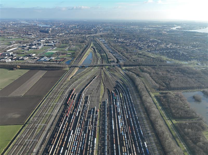
Railyards and rail lines face significant challenges daily—from theft, vandalism, and costly derailments. Technology enables securing their perimeters more effectively while also improve asset inspection practices.

The recent New Jersey drone panic has made it clear: people want to know what’s flying in low altitude airspace. Why can’t we provide the level of clarity demanded? What’s needed to make it happen?

While some industry influencers argue DFR operations are best run up to 200 feet above ground under shielded conditions (only), we explore the risks of this practice as well as the benefits of extending operational altitude with airspace sensors.

In the past twenty years, we’ve seen amazing advances in sensors of many varieties.

There’s a common misconception in the UAS industry when talking about surveillance and operational volumes for UAS operations.
A limitation in UAS operations for DFRs (Drone as First Responder) programs is the requirement for visual line-of-sight (VLOS) of the Remote Pilot in Command (RPIC).
%20for%20BVLOS%20DFR%20Operations-min.jpg)
The future of DFR seeks to eliminate the need for rooftop personnel, or VOs, entirely, simplifying the process into a single-person teleoperation and enabling true BVLOS operations.

We created a mascot based on a MatrixSpacer’s beloved family dog – who loves to be part of everything we do and talk about around the MatrixSpace office.

Classifying MatrixSpace Radar system as solely part of the IoT would be a limiting perspective.

Over a year since Russia invaded Ukraine, one thing is clear: commercial-off-the-shelf (COTS) drones have changed the face of warfare.

Intel Capital’s view is that the next step-function in AI sensing will be driven by diverse multi-sensor approaches combined with AI insights, edge processing and high-speed connectivity.

MatrixSpace CEO Greg Waters gave a speech to the Class of 2023 graduates of the College of Engineering at Northeastern University.
Latest News


PSPD in the city of Palm Springs, California, will utilize MatrixSpace’s low airspace awareness technology to expand the DFR program to cover an area of 37 square miles (95.8km2). This area equates to approximately a third of the city’s total area. Palm Springs now features a network of MatrixSpace 360 Radars, allowing a single PSPD pilot to remotely operate drones from three launch locations across the city. Two more drone launch sites are planned.

MatrixSpace has announced that the Palm Springs Police Department (PSPD) has expanded its Drone as First Responder (DFR) program, establishing the largest first responder agency coverage area (37 square miles) monitored by radar sensors instead of humans in the United States.

MatrixSpace has announced that the Palm Springs Police Department (PSPD) has expanded its Drone as First Responder (DFR) program, establishing a responder agency coverage area of 37 square miles monitored by radar sensors instead of humans. According to the company, the PSPD’s program expansion was made possible with multiple remote drone launch points across Palm Springs utilizing MatrixSpace’s low airspace awareness technology. This has also supported the city’s application for an FAA No Visual Observer flight operations waiver to ensure the safe separation and avoidance of both general aviation and commercial aircraft.

MatrixSpace, an intelligent sensor innovator, announced that the Palm Springs Police Department (PSPD) has expanded its Drone as First Responder (DFR) program, establishing the largest first responder agency coverage area (37 square miles) monitored by radar sensors instead of humans in the United States.

MatrixSpace, an intelligent sensor innovator, announced that the Palm Springs Police Department (PSPD) has expanded its Drone as First Responder (DFR) program, establishing the largest first responder agency coverage area (37 square miles) monitored by radar sensors instead of humans in the United States.